
Mt. Tagapo (438+)

 MT. TAGAPO
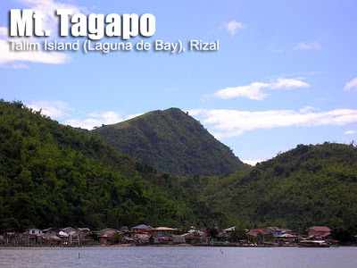
Talim Island, Laguna de Bay
Major jump-off: Brgy. Janosa (Talim Island) Binangonan, Rizal
LLA 14.32° N 121.23° E, 438 MASL
Days required / Hours to summit: 1 day / 2 hours
Specs: Minor climb, Difficulty 2/9, Trail class 1-2
Last updated: February 25, 2015
BACKGROUND
At the heart of Laguna de Bay lies Mt. Tagapo. Its unique geography makes it a worthwhile hiking destination. You will have to board a pumpboat from the towns of Rizal to reach the island; this boat ride will take you to the scenic lake and its fishing villages. You will realize that Laguna de Bay is so huge it’s almost like a sea. Then, on Talim Island, as you start hiking, you will be surrounded with bamboo; the whole island is like a grove, and people live on the bamboo, which islanders use to produce furniture, toothpicks, and even charcoal (hence the name Tagapo, from ‘taga’ which means ‘to chop’).
 Mt. Sembrano. Visible also are Mt. Makiling and a faint Mt. Maculot on its right (SW); Mts. Atimla and Kalisungan (S) and behind them, Mts. Banahaw and Cristobal (SE). The innominate peaks of the Sierra Madre are on the opposite side, and to the far north, even Mt. Arayat can be appreciated. This is not a popular hiking site, but it is recommended, although I must warn you that it can be very hot during the summer.
Talim Island is technically under the municipality of Binangonan, Rizal. Pumpboats ply the routes to different barangays in the island, connecting them to mainland Rizal. Less frequently, there are also trip to Calamba Laguna. Talim island, as its name suggests, is shaped like a blade, cutting across Laguna Lake from south to north. Its uniqueness, as an island community within a large lake, is unparalleled.
The Tagalogs, having a rich imagination, call Mt. Tagapo ‘Mt. Susong Dalaga’. From the towns of Laguna, you can readily spot the peak of Tagapo, which indeed has the form of a young woman’s breast.
ITINERARY
0500 meet up at EDSA-Crossing terminal; take jeep to Binangoan.
0700 ETA Binangonan port, take passenger ferry to Brgy. Janosa.
0830 ETA Brgy. Janosa; register; arrange for guides, start trek
1100 ETA summit, lunch
1200 start descent
1300 back at jump-off, take return ferry
1530 ETA Binangonan
1800 ETA Manila
|
Transportation
|
Public (1) Jeep or van, EDSA Crossing to Binangonan Port [41-50 pesos, 45 minutes-1 hour]
(2) Pumpboat/Ferry, Binangonan Port to Brgy. Janis [30 pesos, 45 minutes] *Note: Hourly ferry trips but it is best to anticipate delays. First trip is at 0600 and last trip at 2130H but some ferries are slower than the others because they stop in more barangays. Double check the last return trip from Janosa to Binongonan with the boatmen or the locals so you can adjust your itinerary accordingly. It is also possible to charter a one-way trip for around P1500. Approximately 2-3 hours travel time because of various stops and delays. Private. Head out to Binangonan via Manila East Road and then take the ferry as above. Approximately 2-3 hours travel time. |
|
Registration
|
(1) Logbook at the barangay hall of Janosa. P20 registration fee.
|
|
Available; assigned at the barangay hall (300 pesos/guide)
|
|
|
Henry Arambulo (Brgy. Captain) -+639435440524
Archie (Guide)- +639216530089 Jose (Guide) – +739465331573 |
|
|
Campsites and waypoints
|
There is a basecamp at Brgy. Janosa near the start of the trek
|
|
Water sources
|
(+) Near summit prior to grassland
|
|
Cellphone signal
|
Present at the jumpoff and n the upper reaches
|
|
River crossings
|
None
|
|
Roped segments
|
None
|
|
None
|
|
|
None
|
|
|
Rattan
|
Minimal
|
|
Hiking notes
|
The entire trek can be very hot and humid especially during the summer months, so prepare accordingly
|
|
Sidetrips
|
It is possible to explore other areas in Talim Island or include Mt. Tagapo as part of a ‘Twin Dayhikes’ with Mt. Sembrano.
|
|
Alternate trails
|
None to our knowledge
|
|
Yes (2.5-4 hours to summit; 1.5-3 hours down on either of the above-mentioned trails)
|
|
|
Facilities at jumpoff
|
(+) Sari-sari stores
(+) Wash-up / shower places |
|
500-700 (dayhike)
800-1000 (overnight) |
MT. TAGAPO PICTURES

The port of Binangonan is the major starting-off point in travelling toTalim Island. This is where the adventure begins!

There is the unique experience of riding a motorboat acros Laguna de Bay to reach the island.

The final leg of the trail is a fifteen-minute assault on grassy slopes to reach the summit.

At the summit of Mt. Tagapo, 438 MASL with my classmate Siena Ona.


Jose Rizal, aboard the Salvadora, wrote in his diary that on their approach to Singapore, there was “a long chain of islands forming a sort of mountain range. They remind me of Talim Island with the Susong Dalaga.” This entry was dated May 8, 1882. In El Filibusterismo, Rizal also mentions Talim Island, as well as Calamba Island – a smaller island in the Lake visible from the peak of Mt. Tagapo.
Geologically speaking, Talim island was once a stratovolcano, and now it is part of what is known as the “Laguna caldera”.
Locals say that there is a rumored treasure on Mt. Tagapo. This explains the open pit at the summit. They also say that the name of the island may also be due to the sharp-toothed crocodiles which used to roam free in the island.
WEATHER OUTLOOK: BRGY. JANOSA, TALIM ISLAND
Leave a Reply
249 Comments on "Mt. Tagapo (438+)"
Umakyat po kami noong August 2, 2015. Sobrang init po ng panahon at matataas ang mga talahib. Maganda po ang view sa summit. Latest contact person:Capt. Arambulo -09435440524; Councilor Dando Anain – 09329289027; Marcelo Arambulo – 09497405561(pwedeng guide). 300 pesos pa rin ang bayad sa guide, pero dahil marami kami nagdagdag na lang kami. May mga nakita po kaming mga basura sa campsite sa taas at sa ibang part ng trail. Kaya hanggat maari po pulutin po natin at dalhin sa tamang basurahan sa pagbaba.
Aakyat kami sa August 2. Okay naman daw panahon according kay AccuWeather.
Hi, Sir Gid and readers of this awesome site,
I'm a relatively newbie mountaineer. I've just recently climbed Mt. Tagapo (5/12/14) and I would like to share my experience:
http://celineism.blogspot.com/2014/06/the-energy-push-at-mt-tagapo-binangonan.html
Do visit my blog if you have the time!
Thanks, Sir Gideon! More power to PinoyMountaineer!
Cheers to the next adventure!
We went up Tagapo last month and reached the summit by 1 in the afternoon. True to its words, maganda talaga sya, lalo sa summit. Kaso, sabi nung guide namin, bago na daw yung trail. Mas mahirap daw kesa dun sa luma.
Tatlo lang kaming umakyat e, ako, yung college friend ko, at si Kuya Nick(guide). 300 PHP po yung guide.
PS: May water source po sa Tagapo. Bago makarating sa summit, may daan dun outside ng trail na lilikuan. Sabi nung guide, may balon daw dun at caretaker kaya malinis yung tubig dun at pwede rin daw magpahinga. Pero may campsite sa mismong Tagapo bago mag summit
Kung may tanong po kayo, pwede nyo ko mahanap sa:
http://elishadenisse15.blogspot.com/
https://www.facebook.com/elisha.denisse
jeep from crossing 41php
boat 30php
guide fee 300php
09489277582
guide kuya gervel
meron nabase camp sa brgy. janosa sir
ingat po, super init lang ngayon dun