
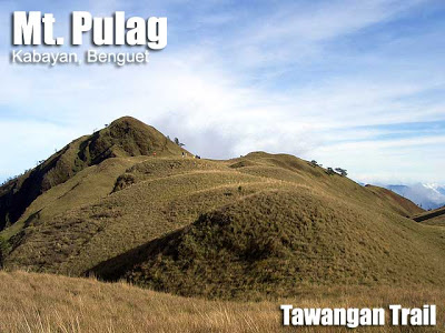
Mt. Pulag/Tawangan Trail (2,922+)

 MT. PULAG (TAWANGAN TRAIL)
Kabayan, Benguet
Major jump-off: Sitio Labang, Brgy. Tawangan, Kabayan
LLA: 16°34’58″N 120°53’15″E, 2922 MASL
Hours to summit / Days required: 10-11 hours / 3 days
Specs: Major Climb, Difficulty 6/9, Trail class 3
BACKRGOUND
Pinoy Mountaineer features arguably the most comprehensive trail to the summit of Mt. Pulag, the Tawagan Trail. This trail is named after the barangay of its orgin: Brgy. Tawangan in Kabayan, Benguet. The beauty of this trail lies in the exuberant display of mosses and ferns in the mossy forest which takes up half-day of the ascent to the summit. After five hours of climbing, the grassland will emerge, and along with it a beautiful stream which counts as a water source. Beyond this is another 3 hours of climbing to reach the saddle campsite and the summit. As of 2008, there are direction markers set up by the DENR to orient you as well as the designate the places for camping. From the summit, it is your choice whether to descend via Ambangeg, Akiki, or return to Tawangan. Your jeepney, if you rent one, can pick you up in your exit point.
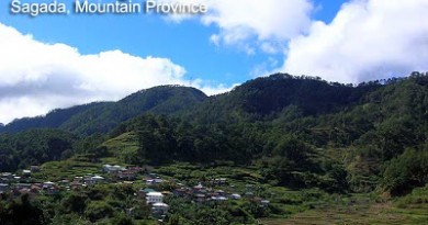
 The town of Kabayan is noted to be a cultural hotspot. Here is the very heart of Ibaloi culture; you may visit the Opdas Mass Burial Cave, the modest Kabayan Museum, as well as other natural wonders such as the lakes that flank Mt. Tabayoc (i.e. Lake Danao, Lake Ambulalakao). Those with cultural interests can really maximize the lengthy travel time and stay one more day to hear the local folklore. For instance, one may wonder how the Opdas Caves came to be. Some say it was a collection of ‘exploits’ by ancient tribesmen; or they may simply have been gathered there from various sites.
In the same way that mountaineers hold Mt. Pulag in high esteem; locals revere the mountain. An ancient belief holds it to be the “Playground of the Gods”; where their spirits used to roam. Indeed, beholding the sea of clouds in the everlasting grassland of Pulag, one cannot but feel a heavenly, lofty feeling.
ITINERARY
(TAWANGAN-AMBANGEG TRAIL)
Day 1
0400 Early breakfast at Baguio City
0430 ETD to DENR-Ambangeg/ Registration*
0830 ETA DENR-Ambangeg / LNT briefing*
0930 ETD to Poblacion, Kabayan
1100 ETD to Brgy. Tawangan. Jeep will proceed further to Taaw River.
1600 ETA Taaw River / Start trek to Sitio Labang.
1800 Sitio Labang Campsite. Water available.
1900 Dinner / socials
Day 2
0400 Wake-up call / Breakfast / Prepare packed lunch / Break camp
0600 Start trek. Prepare for Limatiks.
1200 ETA Water Source (Grassland) / Lunch / Load-up water 4L/pax min.
1700 Mt. Pulag Summit for the Sunset viewing
1830 Arrive at saddle campsite
1900 Dinner / socials
Day 3
0430 Wake-up call
0500 Assault summit
0530 Mt. Pulag Summit / Sunrise viewing…
0700 Back to campsite / Breakfast / Break camp
0900 Start Descent
1100 ETA Ranger Station
1200 ETA Ambangeg, DENR (Log-out)
1230 ETD Ambangeg / Lunch along the way
1700 Back in Baguio City
*As of Jan. 2008, DENR-PAO discourages climbing from this trail.
**note that Day 1 may be spaced in two days for a less hectic schedule
SPECIAL CONCERNS
Security. As of Jan. 2008, DENR-Mt. Pulag National Park discourages climbs from the Tawangan trail, due to security concerns. Coordinate properly with the National Park through Ma’am Emerita Albas to check status of the trail at +639196315402. The website of Mt. Pulag National Park lists Tawangan as one of the trail options but it is not updated; it is still best to contact DENR.
The beauty of Mt. Pulag attracts a lot of would-be climbers; however, PinoyMountaineer advises proper training before attempting to climb this mountain. The temperature may drop to chillingly cold levels (0-5 °C) and proper clothing is recommended. Coordination with personnel of the Mt. Pulag National Park (MPNP) is strongly advised for safety reasons. Pulag is one mountain where revenue is badly needed to maintain the beauty of the mountain.
There are many limatiks in the mossy forest; preparing accordingly. Guides may be arranged at the DENR office at Ambangeg; as of 2007, a P2,500 professional fee must be given for each guide; Mt. Pulag National Park fees would amount to around P200 when using this trail. Still feasible is a P2,500 budget if coming from Manila, given a group of 17-20 people.
The Norton bus caters to passengers coming from Baguio to Ambangeg and Kabayan. There are trips at 0900, 1000, and 1400 hrs daily. However, the best option is still renting a jeep from Baguio.
The Tawangan trail may also be accessed from Hungdungan, Ifugao; an addition 1-2 days is required if starting off from this location.
Cellphone signal is sporadic, but present in some parts of the Tawangan trail. Other useful numbers include those of the regional office of the Department of Tourism in Baguio City (+63744427014) and DENR-CAR with a fax number of (+63744447428).
TRIVIA
Contrary to popular belief, the dwarf bamboo (Yushania niitakayamensis) is not endemic to Mt. Pulag. It is distributed throughout the high peaks of East Asia; and is known internationally as Yushan cane, after Yu Shan (Jade Mountain), the highest mountain in Taiwan at 3952 MASL.
Truly endemic to Mt. Pulag is the giant bushy-tailed cloud rat (Crateromys schadenbergi), considered the biggest rat species in the world. It feeds on pine cones and flower buds, and its body may reach up to 40 cm in length. It is part of the 2006 Red IUCN List of Threatened Species. Another rare species found in Mt. Pulag is the Luzon pygmy fruit bat (Otopteropus cartilagonodus).
Mt. Pulag was proclaimed National Park by virtue of Presidential Proclamation No. 75 on February 20, 1987 covering an area of 11,550 hectares. It was established to protect and preserve the natural features of the area such as its outstanding vegetation and wildlife. It belongs to the Cordillera Biogeographic Zone located in Northern Luzon. Mt. Pulag is a National Integrated Protected Areas System (NIPAS) site
The heavenly landscapes and rich biodiversity of Mt. Pulag makes it the “mecca” of nature lovers and mountaineers throughout the Philippines.
© Pinoy Mountaineer, 2008. All rights reserved.
Leave a Reply
40 Comments on "Mt. Pulag/Tawangan Trail (2,922+)"
hi, possible po ba ang trail na ito within 2 days? Thank you.
Planning to climb Pulag via Tawangan-Akiki trail. Anyone here knows the updated rates of DENR? As well as guide and porter fees? Thanks!
3 po ang water source, sa last water source na kayo mag load ng water to saddle.mga 3 hours ang interval.
Hi! Question lang sa mga nakapag tawangan trail..madami po ba ang water source from tawangan to saddle campsite sa mt pulag ? gaano po katagal ang interval ng water source from another water source ? Thanks..
aakyat ang grupo ng TAPIK tao pangalagaan inang kalikasan.sa dec 26-30 luzon 321 timbak,tabayoc,pulag via tawangan trail,,kung sino po gusto sumama txt lng po kayo…09228552477….ron