
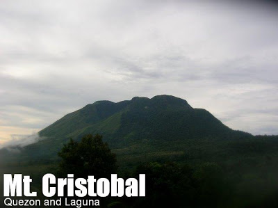
Mt. Cristobal Traverse Trails (1,415+) [CLOSED]


MT. CRISTOBAL/TRAVERSE TRAILS
Quezon and Laguna
Entry point: Sitio Parang, Brgy. Sta. Lucia, Dolores
Exit point (1): Sitio Awas, Brgy. Sta. Elena, San Pablo City
Exit point (2): Brgy. Tala, Rizal, Laguna
Exit point (3): Brgy. Malaya, Nagcarlan, Laguna
LLA: 14.064° N 121.428° E, 1470 MASL (600m gain)
Days required / Hours to summit: 1-2 days / 4 hours
Specs: Major climb, Difficulty 6/9, Trail class 3-4
Note: There is a blanket closure of Mt. Banahaw and Mt. Cristobal which is in force as of the time of the last update (April 2017)
TECHNICAL BACKGROUND
To unify the diverse information about a traverse of Mt. Cristobal, PinoyMountaineer features all the variants of the Cristobal Traverse – including the regular Cristobal climb – in one definitive page, covering the main trail system which consists of the three major landmarks: (1) Montelibano’s House; (2) the crater; and (3) Jones’ Peak. In order to compare and contrast the three, we are creating a master itinerary that starts off from Dolores – in spite of the fact that most conventional climbs start off from the exit points. We are recommending Dolores as an entry point because of its fast access to the crater, and a more established guideship system in Sta. Lucia/Kinabuhayan. For a more rudimentary article about Mt. Cristobal, please see the previous article.
Jones’ Peak, which is the highest point of the Cristobal Trail system, has been identified as the summit of Mt. Cristobal; this is incorrect. The true summit of Mt. Cristobal is southeast relative to Jones’ Peak; it is higher by over 50 meters and is unfortunately inaccessible at the moment. Hence, PinoyMountaineer will prefer the eponymous naming of the peak (after a mountaineer who got injured in the steep descent). Since this is also the best viewpoint in the whole trail, we are recommending the Jones’ Peak be the final destination of the regular Cristobal climb (instead of the crater).
From Jones’ Peak, the trail diverges into three branches: the first major turn northward leads to San Pablo City and Brgy. Tala, Rizal (same trek up the village chapel as Tayak Hill). Take note that the seeming distance between Brgy. Tala, Rizal and Brgy. Sta. Elena, San Pablo if you consider the highway is accounted for by the centripetal orientation of the towns. The outer circle (the highway) may be long but within the mountain itself, Dolores and the Laguna towns are very proximate.
Meanwhile, the trail continues to Brgy. Malaya in Nagcarlan. This trail is usually established during summertime when folks from Nagcarlan climb up the mountain to visit the fiestas in Dolores – and vice versa.
How is the traverse trail like? Here is the rough breakdown:
Dolores -> Crater (4 hours): As described in the original Cristobal page, the first hour consists of ascending to Montelibano’s House. Just follow the cement path up and you’ll end up in the house; be courteous to the caretaker and ask permission to get water if you need it. Don’t be afraid of the dogs. Here, the views of Dolores and Lucena including Tayabas Bay are nice. Then begins the almost nonstop ascent to the crater via a forested trail, the zenith of which reaches a moss density akin to Mt. Makiling. The crater, of course, is also a picturesque place albeit flooded in many an occasion. This leg is discussed in greater detail in the previous Cristobal article.
Crater -> Jones’ Peak (30 mins): Some trekking within the high points of the crater area is done; the highlight of the trail is the wide path in the elevated campsite that is picturesque and reminiscent of grander mountains such as Mt. Apo and Mt. Napulauan. Then, the forest will give way into a labyrinthine path across cogonal fields – leading to the highest point in the ridge and the trail system, Jones’ Peak. From Jones, the views are spectacular, featuring the entirely of San Pablo with its Seven Lakes; northward it is bounded by Mts. Kalisungan and Atimla; Mt. Makiling is also visible further; westward lies the large presence of the Malipunyo Range. It is truly a geographic vantage point; the best viewpoint for the Seven Lakes.
Jones’ Peak -> Green Mountain (3.5 hours) Here lies the most difficult part of the trail, involving a steep descent from the peak. You will have to cling on to cogon – and some segments are roped to assist climbers. Beware of the rattan thorns – as well as the very noxious lipa plants that grow alongside the trail. At the same time, be vigilant for any of the fauna you might see. Still at large are monkeys, wild boar, and snakes in this area of Cristobal. There are also a variety of beetles and other fauna here. The forest will soon give way to the green fields bounding Rizal and San Pablo, but instead of going down, following the northeast, straight trail leads to Nagcarlan.
Sidetrip possibilities exist for each destination: for Rizal, Tayak Hill and the Terraza Verde Resort; for San Pablo, the Seven Lakes themselves; for Nagcarlan, Bunga Falls, and for Dolores, Sta. Lucia Falls and perhaps the curative spring of Brgy. Kinabuhayan.
All said, the Mt. Cristobal Traverse ranks among the more formidable Southern Tagalog climbs, and going for the traverse is must-try for a complete Cristobal experience!
MASTER ITINERARY
Day 1
0900 ETD for San Pablo
1200 Lunch at San Pablo plaza
1300 From market, take jeep to Kinabuhayan
1400 ETA Sitio Parang (jumpoff); Start trek
1730 ETA crater campsite
1800 Dinner / socials
Day 2
0600 Breakfast
0700 Break camp
0800 Take traverse trail
0900 ETA Jones’ Peak (1415m)
BRANCH ITINERARY FOR SAN PABLO (+5 hours)
1000 Start descent from Jones’ Peak
1300 ETA Green Mountain; Turn left to Brgy. Sta. Elena
1500 ETA Sitio Awas; tidy up at Bukal (natural spring)
1700 Take tricycle to highway
1800 Dinner in San Pablo
1900 Take return bus to Manila
BRANCH ITINERARY FOR RIZAL (+5.5 hours)
1000 Start traverse from Jones’ Peak
1300 ETA Green Mountain; Turn right to Brgy. Tala
1400 ETA Brgy. Tala chapel; optional sidetrip to Tayak Hill
1600 Start descent to Rizal town proper
1700 Take jeepney to San Pablo town plaza
1800 Dinner in San Pablo
1900 Take return bus to Manila
BRANCH ITINERARY FOR NAGCARLAN (+6.5 hours)
1000 Start traverse from Jones’ Peak
1100 Keep right instead of continuing descent
1400 ETA Brgy. Malaya, Nagcarlan
1500 optional Bunga Falls sidetrip
1700 Take jeepney to San Pablo town plaza
1800 Dinner in San Pablo
1900 Take return bus to Manila
BRANCH ITINERARY FOR DOLORES (+4 hours)
1000 Start descent from Jones’ Peak
1030 Back at Crater Campsite
1300 Back at jumpoff
1400 optional Sta. Lucia Falls sidetrip
1700 Take return jeepney to Dolores then San Pablo
1800 Dinner in San Pablo
1900 Take return bus to Manila
SPECIAL CONCERNS
Transportation. Lucena-bound buses from Cubao and Buendia all pass by San Pablo City. As of December 2008, the fare is around P140 up to San Pablo 7-11. Actually from any point of San Pablo you can take a trip to the jeepney terminal to Dolores, which is just behind the public market. Fare is P30; From Dolores, take a tricycle to Sitio Parang, Brgy. Sta. Lucia.
Aside from the crater and forest campsites, Jones’ Peak is also a possible campsite though it would be good enough only for two or three tents. Winds are very strong at this point. There is no water source in the campsite, however: the last water source is Montelibano’s House and the first water source on the other side are either the chapel at Brgy. Tala; the spring in Brgy. Sta. Elena; or Brgy. Malaya. However, there is little risk for dehydration as most of the trail has excellent forest cover.
Take note that the crater can become a swamp in the rainy season; if so, two nearby small campsites can accommodate tents. Strong winds plus high elevation equals a cold and windy night when camping, so prepare accordingly.
Cellphone signal is non-assured in the crater campsite, but is strong in Jones’ Peak and most parts of the traverse trails.
A contact number for doing the traverse trails is still Kuya Lito of Brgy. Kinabuhayan; he can guide you around the Cristobal Trails; just specify your itinerary. He may be reached at 09214647618 (2013 updated number). No permits are necessary to climb Mt. Cristobal but we are appealing to all mountaineers to preserve the pristine state of the mountain.
TRIVIA
The usefulness of the hated plants and thorns of Cristobal is a marvel. Rattan thorns that cling on bags, clothes, ears, and skin are actually used by locals as a trap for birds and bats – and the lipa leaves have proved their effectiveness against Japanese soldiers who unwittingly used the innocent-looking leaves to wipe their asses during World War II. The indescribable pain caused to say that “In Dolores, even grasses fight against us!”. As for mountaineers, the treatment for lipa exposure is actually the sap of the plant itself.
RELATED POSTS
The author’s experiences of Mt. Cristobal Traverse are narrated in Hiking Matters #37 and Hiking matters #351.
Leave a Reply
56 Comments on "Mt. Cristobal Traverse Trails (1,415+) [CLOSED]"
Hi mga sir/mam,
plabn kasi namen mag traverse nagcarlan.
hingi sana ng contact number,
thanks
may updated contacts po ba kayo,
plan kasi namen magtraverse nagcarlan.
thanks
weve been there last saturday and sunday.. sobrang steep talaga tapos madulas pa dahil umulan.. mahirap pero worth it..
sir/mam
may nakakaalam po ba ng traverse sa san pablo or nagcarlan?.. tsaka, magkano kaya ang guide fee dito sa traverse na to..
tnx a lot,
vladz
Hi Tootz,
It's reasonable, may suki na kaming jeep pickup from 711 San Pablo to Sta. Lucia Dolores "Cristobal jump off" it cost us 1,000.
But your IT, it cost us around 2,500 for our suki jeep.
And we trust our jeepney driver one time nga 3am kami sinundo sa San Pablo.
We are also there last July 20 & 21 Cristobal Traverse Dolores-Tala din kami.
Thanks,
Gerald