
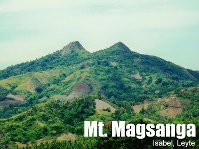
Mt. Magsanga (655+) in Isabel, Leyte


MT. MAGSANGA
Isabel, Leyte
Entry & Exit point: Brgy. Puting Bato, Isabel
LLA: 655 masl
Days required / Hours to summit: 1 day / 2-3 hours
Specs: Minor, Difficulty 4/9, Trail class 2-3
The original article for this itinerary was writen by Shimero Jainga of Ewit Mountaineering Group. PinoyMountaineer.com thanks him and his club for this invaluable contribution. This is his second contribution to the website, after Mt. Lanaya.
BACKGROUND
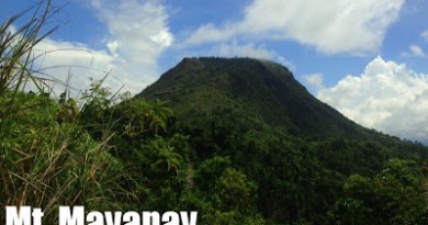
Ormoc City’s skyline is largely dominated by the history-ridden mountain ranges of northern Leyte Island. Yet there’s this curious peak that towers above the city’s western flank, a two-horned mountain silently attracting summit lovers and adventurers alike.
Rising around 655 masl (meters above sea level), Mt. Magsanga forms a silent backdrop over Ormoc’s west landscape. It has a very distinctive outline: the peak forms two sharp horns, which can be traversed on a proper but hazardous trail. There are several trails going to the top, but the most used trail originates from Brgy. Puting Bato, in the town of Isabel, on the island’s west coast. This was where we planned to hike up.
From the time we stepped on the Ormoc port, the twin horns of Mt. Magsanga seemed to beckon us to come, despite the dim and hazy glow of the dawn sun. Indeed, to a die-hard mountaineer, the sight of Magsanga just from Ormoc City proper is strangely very inviting, neither too high to require much climbing preparation, nor too far away to suffer long land trips. Even after we had climbed the mountain it was still awesome to see, especially from the other side of the Ormoc valley. During our tours in the van-for-hire, we still clamored to get a shot of its sharp profile, largely ignoring the cramped conditions inside the van.
From riding a public bus in the Ormoc bus station, our group stopped for breakfast and lunch at our friend’s relatives’ house in Libertad, Isabel. We had a lot of time to socialize, belt out videoke songs, and even catch up with sleep. Past noon, we then rode our way on habal2x going to the jump off point in Puting Bato (literally, since all you see are dirt roads of white stones). Halfway into the rocky road, the mountaineer will be rewarded with a clear and magnificent view of the mountain from the west side. We started our trek on the hot but pleasant countryside, after cooling off at a waiting shed jump off.
The Trail
A large portion of the areas that we passed through were acres of farmland, sometimes even denuded from kaingin pursuits. As a result, we tasted searing hot sun a majority of the way. It was good that there were also adequate shade trees as well as clean spring water sources. The whole time we were trekking, we always managed to catch a good glimpse of the twin peaks, which, for the length of the trip, seemed to loom right above us (which made us all the more excited). Probably the hardest feature about this trail was that it was fairly exposed to the sun, rain, or wind, so if you don’t have protection for any one of those conditions, it could make for a very unpleasant walk indeed.
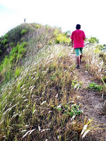
After an hour or so of walking up and down the mountain’s rolling sides, we made an assault towards the peak. I thought it was simply a straightforward trail to the top. No; the trail twisted its way almost around the mountain; we ended up in a sloping campsite facing Ormoc City. Beautiful view of the Ormoc valley. While we still had time, we dropped our bags, briefly took a breather, and ascended the steep northern horn itself.
These last 100 or so meters to the top are no easy feat; the trail is dusty, flat, and consequently very slippery. Surrounding you are tall grasses which are sometimes the only things to grab on when it becomes too steep. Ropes are necessary for a safe ascent, but it still can be done without them, albeit a lot riskier. We scrambled up — doing 4x4s if necessary. The trickiest parts are those that had ravines on both sides and which are obscured by the cogon grass. Yet, when we finally reached the crest connecting the summit, no reward was greater for us than the expansive views of northern Leyte and the “victory walk” that ensued.
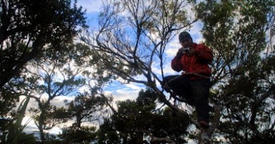
At the top, a 360-degree, clear, unobstructed panoramic view of the other twin peak, farms, hills, mountain ranges on the other side, expansive valleys, Ormoc City, the bay area, and even the Camotes islands, will all justify the hot and itchy climb for the weary mountaineer. The afternoon sun still shone on our backs, but none of us did mind at all. Most of us made sure to visit the entire edge area of the peak just to inhale the scenery. As in all outstanding panoramic vistas, I had to process my reaction to the environment, making sure to savor the moment since this may be the last time I get to climb the mountain.
They say — or perhaps even complain — that Leyte’s mountains are short, unassuming, and pose no difficulty for the daring. From the limited surface area of the peak, we watched the sun go down on its western route; wondering if this mountain has ever disproved them with its unique challenges.
ITINERARY
(from Ormoc City; overnight camp; same trail for entrance and exit)
Day 1
1130 ETD, Isabel
1300 ETA Isabel-Puting Bato junction, ride habal2x
1330 ETA Brgy. Puting Bato jump-off point (waiting shed)
1345 Start trek
1600 ETA north peak campsite, climb to peak
1620 arrive at peak, take pictures
1700 back at campsite, cook dinner, socials
2100 lights off
Day 2
(same way out)
SPECIAL CONCERNS
* There are scattered water sources along the trail, so water supplies are not too much of a problem. The main thing to make sure is to protect yourself along the exposed parts of the trail, whether it be rain or shine.
* When climbing the peak, it is not necessary to bring backpacks. Again, having ropes will make it safer and easier for your group to ascend. The peak can safely accommodate a certain number of climbers; probably around 10-15 (without jostling around of course).
TRIVIA
* If you remembered your history lessons, you’ll recall that northern Leyte was a huge battleground between Japanese forces against the combined Filipino guerrilla and American liberation forces during WWII. Mt. Magsanga may be just one of these fortified Japanese locations, given its strategic position over Ormoc City. Some people (including my ‘gifted’ friends) testify about noticing or feeling other-worldly, Japanese presences on the mountain.
* Although we haven’t encountered one along the trail, watch out for snakes; locals long know the mountain to be the hideout of snakes.
* If the weather permits and it’s clear enough, you can barely see the tip of Mt. Alto — Leyte’s highest peak at 1,500 masl – behind the mountain ranges beyond Ormoc City.
Pictures are courtesy of Shimero Jainga of Ewit Mountaineering Group
Leave a Reply
2 Comments on "Mt. Magsanga (655+) in Isabel, Leyte"
Sir Gid, can you recommend me a guide for mt. Magsanga.m Thanks!
how did you figure the supposed altitude of 655 meters? i don't think mount magsanga is that high. if you have a look at the terrain layer of google maps, http://maps.google.com/?ll=10.952,124.494&t=p&z=15 , you see that the highest elevation in the area is 540 meters. double-checking the altitude in google earth and opencyclemap ( http://www.openstreetmap.org/?lat=10.9532&lon=124.49316&zoom=16&layers=C ) would suggest to me that the real altitude of mount magsanga is around that value, ie. 540 meters.
alto peak, by the way, is not 1,500 but 1,325 meters. i know because i've been there with a gps. my friends also brought theirs, so we could be sure 🙂
like your blog – keep up the good work!