Pantingan Peak – Mt. Mariveles (1,388+)
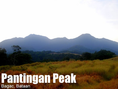
PANTINGAN PEAK – MT. MARIVELES
Bagac, Bataan
Major jumpoff: Gabon, Sitio Duhatan, Brgy. Saysain, Bagac
LLA: 1388 MASL
Days required / Hours to summit: 1-2 days / 6-9 hours
Specs: Major climb, Difficulty 6/9, Trail class 2-4
Features: Views of Mariveles Range
BACKGROUND
The highest peak in crater rim of Mt. Mariveles, and thus, its summit, is Pantingan Peak, consequently the highest point in the province of Bataan, and one of the prominent peaks of Central Luzon. Mt. Mariveles is more known for Tarak Ridge, with its scenic, windy rockscape, overlooking Manila Bay and South China Sea. Whereas Tarak is an outward-looking viewpoint, Pantingan is more introspective, in the sense that it offers a wide-angled view of the caldera of Mariveles (yes, it is, or was a volcano) as well as the peaks that surround it.
It was in the early 1990s when AMCI, led by Sky Biscocho, pioneered the exploration of the Mariveles Range. Tarak Ridge, a product of this initiative, became a popular hiking destination. The other peaks, however, did not receive as much attention, and until now, they remain in a relatively pristine state. Pantingan Peak, considering, its proximity to Manila, can make for a very nice and challenging dayhike or a still-challenging two-day climb.
The climber will first pass through a forest; then grassy slopes will lead him to the base of Pantingan Peak. The trail gets steeper, yet the climbing is pleasant because of the forest cover. From Subuangan Campsite, a small campsite less than an hour from the summit, it is a continuous ascent, and the final part is quite steep, and the trails are overgrown. After this final challenge, though, there is the reward of reaching the summit, and seeing the breathtaking views of the Mariveles range.
ITINERARY
Extended Dayhike
0015 Assembly at Five Star Bus Terminal Cubao
0100 Take first bus to Balanga
0330 ETA Balanga Terminal. Take jeep to Bagac Market
0430 Arrival at Bagac, take tricycle/jeep to Gabon, Sitio Duhatan, Brgy. Saysain
0500 ETA Gabon (Aeta Community). Arrange for guides with Mang Rey Jimenez.
0530 Start trek
0615 ETA River
0645 ETA Nursery
0705 Enter grasslands or “Marlboro Country”
0835 ETA Danny’s Gate
1035 Arrival at Subuangan campsite
1135 ETA Pantingan Peak. Lunch and Rest.
1200 Start descent
1400 Back at Danny’s Gate
1630 Back at jumpoff. Wash-up.
1700 Proceed to Bagac Market. Ride jeep/bus to Balanga
1800 ETA Balanga. Ride bus to Manila
2100 Back in Manila
Overnight
Day 1
0215 Assembly at Five Star Bus Terminal Cubao
0230 Take bus to Balanga
0530 ETA Balanga Terminal. Take jeep to Bagac Market
0630 Arrival at Bagac, take tricycle/jeep to Gabon, Sitio Duhatan, Brgy. Saysain
0700 ETA Gabon (Aeta Community). Arrange for guides with Mang Rey Jimenez.
0800 Start trek
0845 ETA River
1045 ETA Nursery
1205 Enter grasslands or “Marlboro Country”. Lunch.
1400 ETA Danny’s Gate
1735 Arrival at Subuangan campsite
1800 Dinner / socials
Day 2
0500 Light breakfast
0600 Commence assault of Pantingan Peak
0700 Arrival at Pantingan Peak
0800 Head back to campsite
0845 ETA Campsite
0900 Brunch / break camp
1000 Start descent
1300 Back at Danny’s Gate
1600 Back at jumpoff. Wash-up.
1730 Proceed to Bagac Market. Ride jeep/bus to Balanga
1830 ETA Balanga. Ride bus to Manila
2100 Back in Manila
SPECIAL CONCERNS
Guides and permits No advance permit is required to climb Pantingan Peak, but considering that there are only very few guies who know the trail, prior arrangements with Mr. Rey Jimenez (guide) is recommended. He may be reached at 0928.260.96.45.
Getting there. Take the Bataan Transit (in Five Star Terminal, Cubao), Genesis, or any other bus that heads to Balanga and get off at the terminal, from which you can either take a jeep to Bagac Market, or make direct arrangements for a jeepney to the jumpoff. For the dayhike, renting a van or taking a vehicle from Manila is the most expedient option.
Trail notes. The last part of the trail, leading to the summit, is quite overgrown and thorny; noxious plants abound. Exercise the necessary precautions. On the other hand, the first part of the trail is supposed to have a lot of beehives and even a slight provocation can cause some trouble, as has happened in the past, according to the guides. Follow his advice on how to proceed.
PANTINGAN PEAK PICTURES
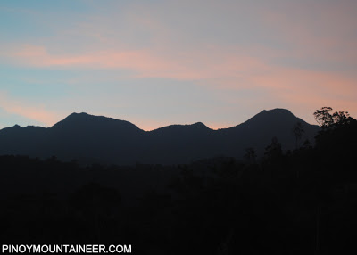
Dawn along the trail. Pantingan Peak is the high peak on the right.
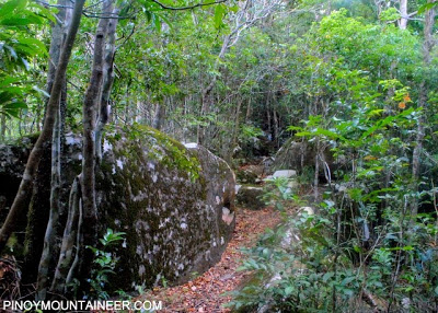
The forest leading to Pantingan Peak is reminiscent of some other Central Luzon hiking destinations such as Tarak Ridge, Natib, and Arayat.
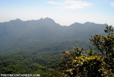
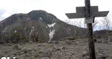
At the summit of Pantingan Peak, you can see the wide caldera of Mariveles the volcano, and the other peaks of the caldera rim.
TRIVIA
According to Sky Biscocho, Pantingan was first climbed in 1996.
PinoyMountaineer.com thanks Sir Martin Cortez for organizing the climb which he joined in April 2011, as well as Sky Biscocho for providing some background during and after the climb.




Leave a Reply
43 Comments on "Pantingan Peak – Mt. Mariveles (1,388+)"
sir & mam, need po namin new number ni sir rey yung guide sa mt pantingan, thnks po
sino po me new number nung guide sa Pantingan na si mang rey?
Hi, anyone interested to join me on Pantingan Peak – Day Hike this coming Sunday? Text me at 09175949646
mga sir baka din po meron kau contact n pde rent n jip from balanga terminal to jump off. tnx po. pde nyo din po itxt sakin 09437257815 09192209270 tnx po.
mga sir magkno po rate ng guide sa pantingan overnyt po ? tska po ilan kasya tent kung s summit mag camp? tnx- vhaturgo